Lee's Landing is the area in the Park below the Lower Falls where the gorge opens briefly before entering the Big Bend (Great Bend) area. You can reach it from the Lower Falls parking area along Trail #5. In modern times it is a nice place to hike since you can access the actual river bed. It is the place where rafts, canoes, and kayaks can enter for the scenic passage through the Big Bend area of the gorge. This location has been significant for centuries. Early maps of the Cottringer Tract show it as one of the early river crossings in pioneer times. Those maps also show George Williams to be the owner of the area, but the earliest name associated to the general area is "Roger's Bridge". In her book "Genesee Echoes," Mildred Anderson writes "About half a mile below the Lower Falls was a place where all the lumber from the surrounding farms was drawn and formed into rafts to ship to Rochester. Two sawmills were located there, one on each side of the river. Known as the Rogers' farm, it included the flat land and the hillside where the present swimming pool is located. Along the river level there were several acres of flat land where a large barn and a house had built previous to 1849. This was 'Rogers' Hotel." A bridge across the river at this point was known as Rogers' Bridge." Mrs. Anderson knew the area well, since it was the place that she was born and raised. Her grandfather Henry Lee had purchased the area in 1878 and the Lee family lived there until 1925, hence the name "Lee's Landing." Beyond the Cottringer Map itself, the first document relating to area is the "Act to authorise William R. Rogers and others to erect a Dam across Genesee River, in the Town of Nunda, in the County of Allegany" that appears in the New York State Laws of 1825. (see below). That area was the Town of Nunda until 1827 when the town of Portage was split off. Nunda and Portage were part of Allegany County until 1846. The act authorized Rogers and his partners to "erect a dam not exceeding four feet in height across Genesee river, below the large falls, and above the falls in the town of Nunda, which are said to be four or five feet...."
|
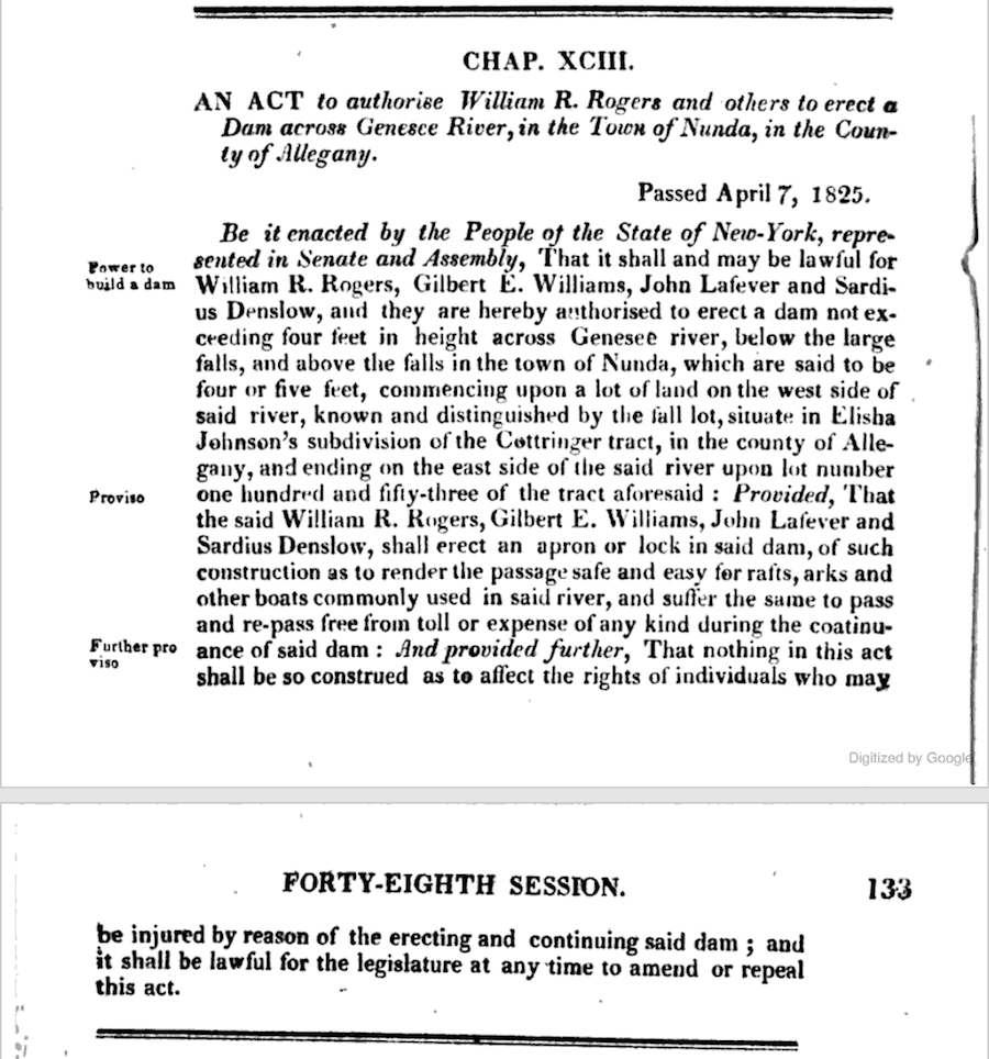 |
The large falls in this statement would be the Lower Falls. The smaller falls would be the rapids on the north edge of Lees Landing which marks the spot where rafts enter the river. As you can see by the 1833 of the area below, the dam was actually built. It is likely that it powered the sawmills mentioned by Mrs Anderson. |
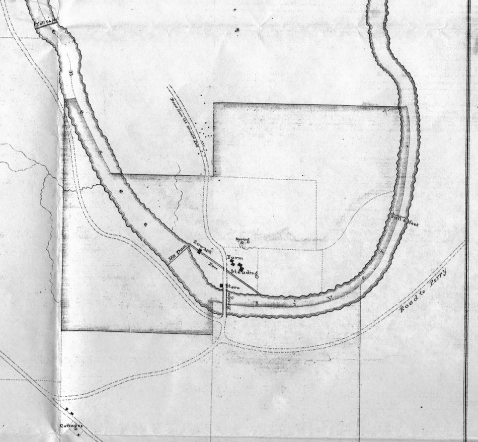 |
North is to the right on this map. The top half will eventually be Wyoming County, the bottom portion, across the river, Livingston. At the time of the map it was all Allegany County. Roger's Bridge is clearly seen in the middle of the image crossing the Genesee River, with the mill pond slightly upstream (left). The road system to the east (down) of the bridge is interesting. The "Road to Perry" that extends to the north (right) probably leads up on Big Bend and down to the ford that was up river from St. Helena. From there it would go north up the valley through Gardeau, eventually leading to Perry. The road that continues through to River Road (where "cottages" are indicated.) The road that goes southward (left) just after crossing the bridge is probably the "Old Carrying Road" - the modern day Park road that leads from the Parade Grounds to Cabin Area E. At Roger's Bridge is found a sawmill, mill race, store, a spring and "Steading Farm". Mrs Anderson mentions the property as once belonging to a Williams James, and that the James Piper Family lived there from 1849 to 1861. Her grandfather, Harvey Lee, bought the land from the George Williams family in 1878. Little is known of the Rogers or Steading families. The Lower Falls is labeled to the upper left on the map. Today the area once called Roger's Bridge is called Lee's Landing and is one of the few areas were visitors have access to the river bed. Also see our 1853 Map of the Portage Falls Area and our 1872 Portage Map. |