Portage Falls Area 1853 Town of Genesee Falls, Wyoming County |
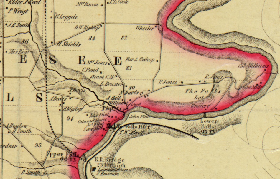 |
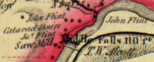
The map above is from the 1853 Wall Map of Wyoming County New York. We are using it for a discussion of the area that became the focus of William Pryor Letchworth on that day he stood on the wooden Erie High Bridge and decided that he would acquire the land at the Middle Falls -- one of the three water falls known collectively as “Portage Falls”. On the image you will find the three falls along the river marked Upper Falls, 66ft, Middle Falls, 110 ft, and Lower Falls 93ft. (The height of Lower in 2018 is much less due to river action. ) We begin at the southern (bottom) portion of the map. The blank portion of the map in the lower right hand corner is the town of Portage, Livingston County, that will be covered on a future page. Only one structure appears on this portion of the map and is marked Lauman House, N. Emerson. This was the predecessor of the famous Cascade House and might have been located at the same location. The hotel was named for George Lauman, one of the three contractors who built the famous Portage Wooden Bridge. N. Emerson was the gentleman who ran the Lauman House at this time. Just above the Lauman House is the label R.R. Bridge. The recently replaced Iron “Spider” Bridge and the new Arch Bridge has been the subject of much public attention in 2017 and 2018., but what is seen as R.R Bridge on this map was the first Portage Bridge, constructed of wooden timbers. Without this world famous engineering marvel, there would be no branch of the Erie Railroad system once known as the Buffalo and New York City railroad. The bridge was finished in August of 1852 just one year before the map was made and about five years before the day William Pryor Letchworth got off a stopped train, as many passengers did, and was so impressed with the view he decided to try and purchase land at the Middle Falls. Thus the germ of an idea which grew into Glen Iris Estate and Letchworth State Park was formed at this location. (Mr Letchworth would in 1875 watch from the lawn of Glen Iris as the wooden bridge burned in a much publicized conflagration.) From the R R Bridge the tracks, shown by a dashed line, arcs west and then due north. That is the location of the original railroad which was relocated in 1880 to the “S” shape that existed up until construction of the new arch bridge. December of 2017 was the debut of the first train over the new bridge. Newly added track sections are said to be 1200 feet on each end. The park acquired the curved section of the old railroad bed in October of 1954 and it contains the old reservoir that the railroad had constructed. Trail #2 can be used to access the feature to this day. The curved section of the park boundary as shown on the modern park map as the northwest corner of the park is the railroad parcel. The heavy dark line between the bridge label and the river is the Genesee Valley Canal. The canal continued beyond this section of the map and crossed the river from Livingston County into Wyoming County on an aqueduct at Portageville and continued on south to join the Allegheny river. It operated through this area until 1878. The red coloring is used by the cartographer to show the Wyoming County line.
There are several names on the map near the falls. James and John Flint appear on structures on the west side, and T.W. Alcott appears on the Livingston County side. Little is known of the Flints, except that the family was centered in nearby Pike and made a lot of land purchases in the 1840s and 50s. Robert, George, and John all purchased land in the Cottringer Tract in the town of Genesee Falls, with George purchasing almost two acres near the Middle Falls in 1855. The John Flint, who was around 24 when the map was made, is listed as an “innkeeper” in the 1850 census. Ja(me)s Flint, who might have been his cousin was a farmer. Both these men had lived in Pike when the 1850 Census was taken. It is thought that the Flint Brothers built the stairs that once took tourists down the Dehgayasoh Falls to the bottom of the gorge. “T.W. Alcott” was Thomas W Olcott (1795-1880), one of Albany NY’s leading bankers and philanthropists. Thomas and his brother Theodore had started buying property in the falls area from some of the original pioneers in 1824. The majority of the land that Mr. Letchworth acquired in the 1858-59 time period was owned by the Olcotts. You will note the Cataract House overlooking the Middle Falls. This was probably the Glen Iris. It is believed that it was being operated , possibly by John Flint, as a temperance tavern at the time. The road Above the Cataract House and John Flint labels that goes west (left) is the road presently in use by the public to reach the Council House grounds. Beyond that area it is now a part of Trail #2 and does not extend past the railroad as shown on our map. It originally connected to Denton Corner’s road and was one of early ways of reaching the Middle Falls area.
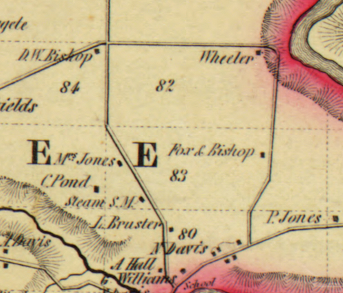
You will find several other Davis properties on the map. A. Davis was Anthony Davis, Nathan Jr’s brother. Some Davis properties in the area were acquired by Mr Letchworth but not the one along the creek. It remained in the Davis family and operated as a refreshment stand until the 1920’s when it was acquired by the American Scenic & Historic Preservation Society. The Society was the Park manager as designated in Mr Letchworth’s gift agreement with the State of New York. If you look closely, a structure marked school appears east of the Davis property, between the roadway and the gorge. This was the original location of the local district school for area children. Because of the precarious location of this one room school, Mr. Letchworth later had a new school house built in a better location. A replica of the second Letchworth School House stands on present day Trout Pond Road. A short distance above Davis and the school is the name G. Williams. This is one of the many properties owned by the man known as “Colonel” George Williams. He was a land agent for the Cottringer Tract in the area and thus had easy access to ownership of many properties. In later years his heirs sold property which became part of the park on both sides of the river. The road at that location that goes north is the Glen Iris road, at that time the prime access route to the Middle falls area. Along the road you will find the names A. Hall and I. Bruster. Abner Hall and his wife Betsey (Fancher) lived in the area until the late 1860s. Two of their children are found in the Pioneer Cemetery. The latter name is actually Isaac Brewster. According to Mildred Anderson’s “Genesee Echoes”, Isaac came to the area in 1841 and married the daughter of Perry Jones. He later worked for Mr. Letchworth. The road that goes east (right) from the Glen Iris Road was known as the “River Way” and was the primary route to the Lower Falls area, and what is now Lee’s Landing. The modern park road generally follows this old roadway past today’s Inspiration Point to the Visitor’s Center/Administration Building. (If you look closely when driving this section you can still see some of the maple trees that had been planted along the road in Mr. Letchworth’s time.)
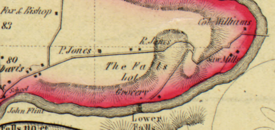
Continuing along the old River Way is the name R. Jones. This is Reuben Jones, brother of Perry, whose farm was called Chestnut Lawn. (Mr. Letchworth gave the Jones farms the names Prospect Home and Chestnut Lawn after acquiring the property. ) The two brothers, along with much of their family, are buried in the Pioneer Cemetery on Trout Pond Road. The site of Chestnut Lawn location is now Group Camping. It is also the place where present day hikers can pick up Trail 4 which follows part of the old River Way. Beyond Reuben’s farm the road bends and then has a sharp fork, with one branch leading to the Lower Falls and the other to the area which has been known for more than a century as Lee’s Landing.
Lee’s Landing on a present park map is the part of Trail 5 where it ends at the river and is the starting point for the rafting and canoeing offered in the park. This was also true at the time of the map, for this area was the access point where local lumbermen and farmers built rafts on which they could float their products downstream to market. The River Way crossed the Genesee on “Roger’s Bridge,” an important crossing as early as the 1830s. Just down stream from the bridge would be what Mildred Anderson in her books describes as a “four foot” falls known as the Rafting Place. Much of this area, including the Saw Mills found on the map belonged to George Williams at this time. There is an interesting letter to Mr. Williams by Edward Hunt written in 1851 what discusses the preservation of this area of the gorge. On the map the other branch of the River Way goes directly to the Lower Falls. It is interesting to see Grocery labeled near the falls. This area was a popular with adventurous visitors who made they way down to Table Rock to view the flume and falls. The Grocery may have been a place for these tourists to both rest and replenish their supplies. We have no details or explanation of this term. This 1853 Map offers an interesting depiction of the area shortly before Mr Letchworth began his development of Glen Iris estate. You can follow the development of the area through the 1866 and 1902 Wyoming County, the Minard Map, and other early Park Maps found on this website. |