Building the Glen Iris Estate
Part 2
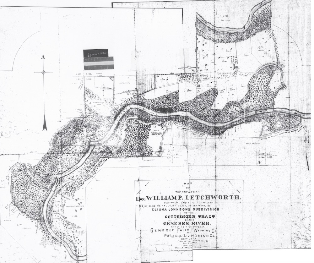
As we discussed in Part 1, we recently researched how Mr. Letchworth acquired the lands of his original Glen Iris Estate which he later gave the State of New York. In the first part, we provided a chart listing the many purchases he made between 1859 and 1898. In Part 2 we present a physical representation of the land acquisitions divided into four time periods. To do this, we used the Minard map from 1890 found below. This is the most detailed map of the original Glen Iris Estate and reflects the lands as described in Mr. Letchworth's deed to the State. For a detailed look at this wonderful map, click here. It may also be helpful to examine the Cottringer Map, which shows the various Lot numbers so important to this topic. After each of the four maps of the land acquisition we will discuss some interesting facts and details pertaining to that particular phase. Our markings on the maps are only approximate, but help us to understand the physical development of the Glen Iris Estate. |
 |
Before we begin, however, it is important to set the stage for the initial purchases of what would become his beloved Glen Iris Estate. (Also see our Glimpse of William Pryor Letchworth and The Story of the Glen Iris Inn for additional background.) William Pryor Letchworth was a successful Buffalo NY businessman who was looking for a summer home. In early 1858 he happened upon the Portage Falls area that he first saw from the top of the Portage Wooden High Bridge. He fell in love with the spot, and according to his biographer, J. N. Larned, "he returned to Buffalo with fragments of information concerning the mill property (area around the Middle Falls) and adjacent pieces which led him to conclude that it would not be impossible for him to buy what he desired at no extravagant cost....Negotiations to that end were opened presently, but did not run with smoothness to an early consummation. The land necessary for taking in to one estate, on the west side of the river, the view that embraces the upper and middle falls, the plateau above the latter and the hillsides behind the plateau was in a number of hands. Mr. Letchworth would purchase none of this if he could not purchase all. Some of the first offers proposed to him were rejected emphatically, and the negotiations appear to have been at a standstill for several months. He then submitted to the several owners a proposal which he assured them was an absolutely final one, beyond which he would not go. They understood, evidently, that he meant what he said, and ... the conveyance he desired (was) made to him . It actually took him about three years to fully secure what would be the core of the Estate - what we have marked below in green in our First Phase map below. |
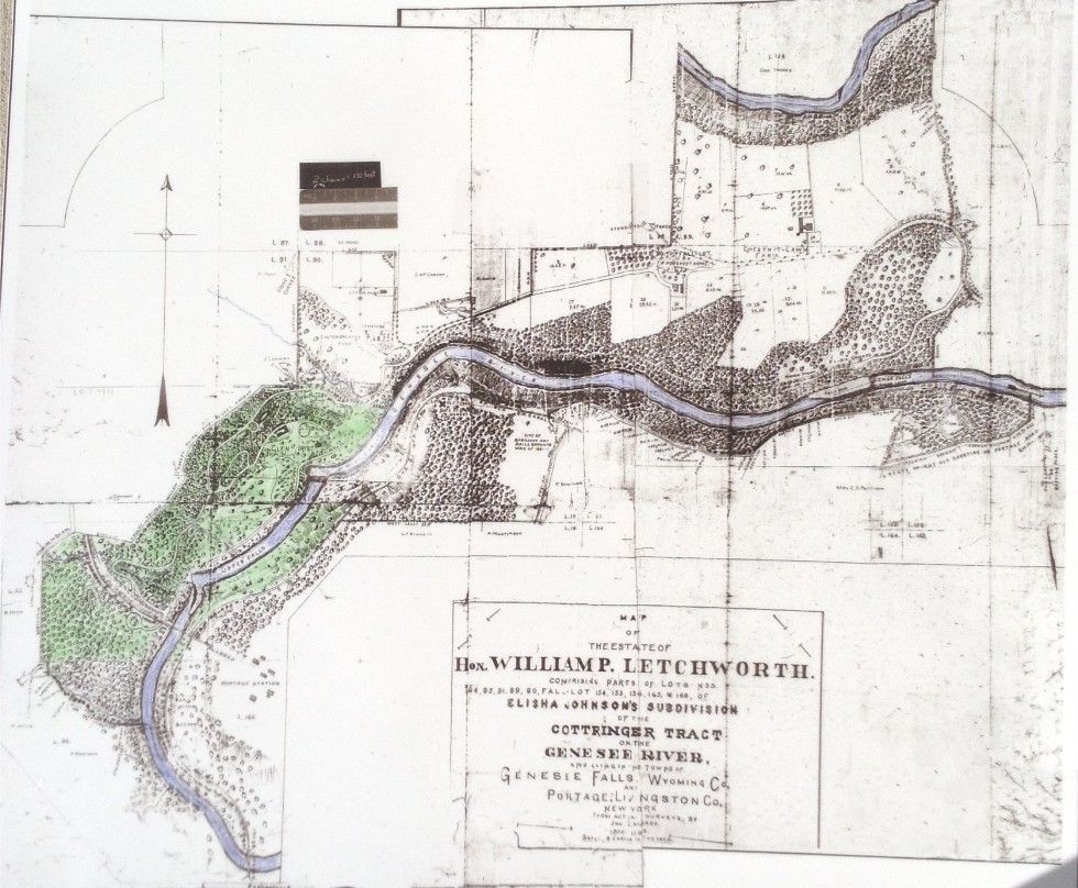 |
FIRST PHASE MAP The green shading represents the intitial purchases Mr. Letchworth made from December 1858 into 1860 and represents the beginning of the Glen Iris Estate. All the acquired land was in Lot 94 of the Cottringer Tract as laid out by Elisha Johnson. (See the Cottringer Tract Map for a clearer understanding of the different lots.) This nascent estate stretched from on the west side near the south bank of Erickson's Brook (which Mr.Letchworth and his friends would later rename "Degayasoh") to some acreage south of the Portage Bridge. There was also a strip of land along the eastern side of the river, reaching from the river bank to the towpath of the Genesee Valley Canal. As shown on the Tabulation of Land Acquisition, Mr. Letchworth had to purchase eight parcels, ranging in size from .2 acres to over two hundred acres to create this foundation of his new home. Please note that we were not able to pinpoint the location of many of the smaller parcels more precisely than to put them in Lot 94. The main acquisition consisted of 202.4 acres that included the house that would become the Glen Iris, the mill remnants of Middle Falls, and much of the hillside to the west. These were the lands held by Thomas Worth Olcott of Albany NY. Olcott was a banker and one of Albany's leading citizens. He had started to purchase lands in the Cottringer Tract as early as 1824. His brother Theodore, a banker, also bought Genesee Valley lands. It appears that it was Theodore who became involved with Michael Smith, builder of the frame house that would become Mr. Letchworth's home. Both Smith and Theodore Olcott had run into financial hard times, so by the time Mr. Letchworth inquired about purchasing the site, it was Thomas Olcott who actually sold the land. Because of this complicated situation, Mr. Letchworth took careful steps to be sure that he had full and clear title to the property. We should note that we were never able to find a lawyer involved to help Mr Letchworth with this or his other land deals. The Michael Smith deed is a quit claim and another illustration of Mr Letchworth’s caution in making sure no possible claims to ownership could be raised against him. Since Smith was at one time was linked to the Olcott property his quit claim deed was for all of Lot 94, 95, and 165 just to avoid later claims. Although we knew that mills were once built at the Middle Falls, we found out that, according to the deeds, there were multiple locations formally designated as a “mill site". The Olcott deed contains metes and bounds descriptions of mill site one, two, four and the statement that four is adjacent to five. (When a property description contains a precise angle and distance for one side such as “North forty-five degrees east, 20 chains” this in known as metes and bounds description by realtors and surveyors.) We think that the missing mill site was on Deh Ga Ya Soh creek upstream from the Davis Cottage. That “cottage” (also known as the Davis Homestead) existed for many years up hill from Glen Iris across the creek from the road junction where the road to Council Grounds branches off the main road. It was actually a post card subject in the early 1900’s. The Olcott deed also conveyed water power privileges, and the mill sites mentioned above plus the mill building, recently burned, and the mill still existing. It should be noted that the Davis Property mentioned above ("C" on the map below) was never part of the Glen Iris Estate. The John Wright sale (see the Tabulation in Part 1) to Mr Letchworth is interesting because Mr Wright was actually the Sheriff of Allegany County and he had foreclosed on owner Edward Palmer because of a lawsuit. The property was sold at auction in 1841 ( a year before Wyoming County was formed.) The property was auctioned, but the person failed to pay the bid of $58.33. Mr. Letchworth was able to consummate the deal by paying that amount in 1860. This same piece of property is also included in a deed from Perry Jones & Sally Ann Jones and is one of the things we were not able to fully understand. At this time Mr Letchworth acquired the right from the Olcott family to settle with the State of New York for damages caused by canal construction in Lot 165 of the Cottringer tract. In those days the State constructed the canal and then negotiated a payment with affected landowners. We did not look for any record that Mr Letchworth or anyone else received such payments. Mr. Letchworth wasted no time in consolidating his purchases into his new estate. He hired landscape architect William Webster to design what was called an "Ornamental Farm". (Use the link to view Webster's description and map of the early Glen Iris Estate. Although his initial purchases generally fulfilled his goal of securing the land around the Middle Falls, William P Letchworth wasn't through building his estate. Retiring from business in 1871, he was able to focus on adding lands beyond Dehgayasoh Creek to his holdings. His purchases between 1866 and 1876 are indicated in yellow below. |
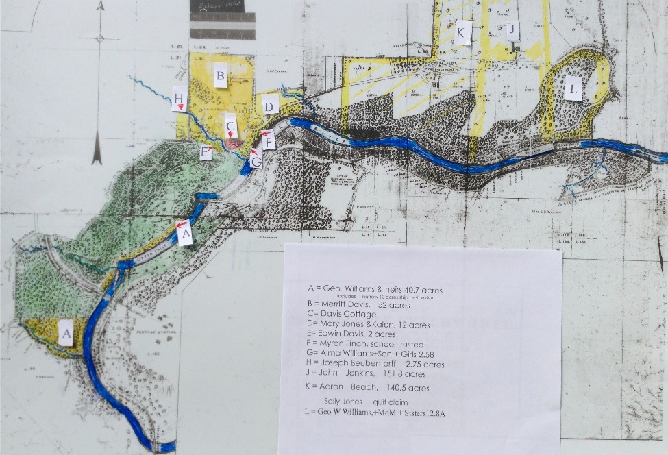 |
SECOND PHASE MAP We can now map the next phase of Mr Letchworth’s acquisition work that spans 1866 to 1876. For this time period, we have attempted to show the various parcels both through different shading and with letters that are explained in the key. Among these parcels is one that involves some interesting public service activity which Mr. Letchworth is so well known for. The Merritt Davis property of 52.4 acres (Parcel B on the map) borders Glen Iris road. The deed to Mr Letchworth makes reference to a “school house lot” and the “public burying ground." At this time the local district school was located, according to Mildred Anderson, "on a little plateau like area between the road and the river bank about half way down the hill to Glen Iris", which placed it near the edge of the gorge between the modern day Soldier's Monument and Degayasoh Bridge. It was, to say the least, a precarious place to have a school. When Mr. Letchworth bought the land from Merritt Davis in 1870, he included in the deed mention of a "new" school lot, well away from the gorge. There is no metes and bounds to define the parcel so it appears to be a gentlemen’s agreement. The metes and bounds for the new school lot was set off in the deed from Mr Letchworth to the school district on the same day that the school lot perched on the edge of the gorge (F) was deeded to Mr Letchworth by the school trustees. This is three years after the first mention of the school lot in the Merritt Davis deed which was obviously a show of good faith to get the school trustees moving to eliminate what must have been a nerve wracking location in the minds of parents. (You can use these links to find out more about the Letchworth School House and the Pioneer Cemetery.) The Merritt Davis property along with others he purchased to the north during this time period allowed Mr. Letchworth to become "a gentleman farmer" of sorts. Three separate farms would take shape; Lauterbrunnen, Prospect Home, and Chestnut Farms. These would be actual working farms operated by tenant farmers, and in addition to hay and other crops, Mr. Letchworth would build a prized herd of cattle. This was also the time he began to develop the Council Grounds on land that he had acquired from Olcott in the first phase of purchases. The John Jenkins parcel (J) is actually Chestnut Lawn Farm and was at a time when families like the Jones one were losing patriarchs and disposing of property they could no longer manage. The same was happening with the George Williams family with young George W. his sisters and his mother Alma selling as heirs (parcel G). This is also the situation with the Aaron Beach purchase (K) by Mr Letchworth of Prospect Home Farm with a quit claim by Sally Jones, a widow of Perry Jones again protecting himself from future claims. (George Williams was an early settler and land agent for the Cottringer Tract.) The two acre parcel sold by Edwin Davis (E) is west of the Davis Cottage (C, red on map) and he was acting as heir of Nathan Davis. The 2.58 acre piece (G) east of the Davis Cottage was purchased from Alma Williams and the other heirs of George Williams and is the northeast corner of lot 94 of the Cottringer tract. These pieces were up the hill from Glen Iris at the road intersection where the Davis Cottage is situated. The precarious school lot (F) is not identified by metes and bounds but lies in Lot 90 on the north side of the 2.58 acre Williams parcel which is the Lot 94 northeast corner. We now begin a small edit of the Minard map because he did not show the 2.75 acre Joseph Beubentorff parcel (H) which Mr Letchworth sold him in 1864 for $1 and bought back for $150 in 1870. (Please note that there are several spellings of the Beubentorff name. We are using here the spelling as found in the deeds.) The deed clearly spells out that it is the southeast corner of Lot 91. This parcel is included again in a later phase of acquisitions in 1898 because Mr Letchworth turned around and included it in the sale to King in 1872, who sold it to Conway and as a final move it comes back to Mr Letchworth in 1898. In the next phase of purchases, Mr. Letchworth will complete holdings on the west side of the river and acquire additional lands on the east side of the river. |
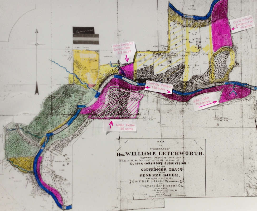 |
THIRD PHASE MAP
This brings us to the last phase in Mr. Letchworth's land acquisition.
|
 |
FOURTH AND LAST PHASE MAP
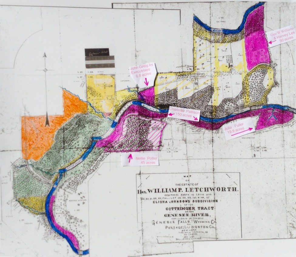
In the yellow phase we show the southeast corner of Lot 91 being owned by Joseph Beubentorff. We now show that area in orange because in 1870 Mr Letchworth had bought the parcel back from Beubentorff and sold it along with the rest of the orange parcel to Alonson King who in turn sold it to James Conway who now has passed away and the land is purchased by Mr Letchworth from James D. VanArsdale. At the end of the 1906 deed to New York from Mr Letchworth, the wording is ”The above lands are also identified by a map annexed hereto as a part hereof for further identification marked Map of the Estate of Hon. William P Letchworth… from actual surveys by Jno. S Minard 1870-1890” Then the writer of the deed, who we do not know, states “Also all those certain pieces or parcels of land situate in said Town of Genesee Falls and subsequent to the time of the making of said map…” and what follows is the text of the deed from James H VanArsdale. There are a number of parcels listed in that deed we could not fully plot besides the one major one we show in our orange phase.
For a look at park land acquisition after Mr. Letchworth's death please see The Park Grows.
|